About port
JSC “Murmansk Sea Fish Port”

Murmansk Sea Fish Port is situated in the southern part of the Kola Bay at a distance of 27 miles from the Barents Sea.
Coordinates of its territory and water area of fish terminal are the following:
on South – parallel 68ᵒ 55’46ᵒ of northern latitude;
on North – parallel 68ᵒ 58’10ᵒ of northern latitude.
The navigation in the port is performed day and night and all the year round. The alternation (interchange) of flood-tides and ebb-tides happens approximately every six hours. The difference in the water level between them is 3,66 m. The working depth at the berths can vary depending on the ebb and flood currents. The actual depth at the berth consists of the working (declared) depth, height of the flood-tide at present moment and amendment of the “Tide-gauge” with its sign (mark).
The Kola Bay is navigable all the year round (doesn’t freeze) but if winter is very severe the Bay can cover with ice for a short period of time. In ordinary winters we can see drifting ice on its surface.
Depending on the flood-tides and ebb-tides the density of water in the Bay can vary within 1,000 – 1,025%.
JSC “Murmansk Sea Fish Port”, the operator of sea terminal, is a transport company, which exploits sea terminal, which forms the complex of the following objects of the sea port infrastructure: reloading terminal of northern and southern cargo areas and coaling base. Reloading terminal is used for operations with cargoes (general and bulk), including their transshipment, servicing of fishing and transport vessels and other vehicles. Coaling base is used for operations with cargoes (general and bulk), including their reloading, servicing of vessels and other vehicles.
The part of the territory of the northern and southern cargo areas forms the permanent sea combi many-sided checkpoint across the state border of the Russian Federation in the sea port “Murmansk”.
JSC “Murmansk Sea Fish Port” holds big vacant open warehouse areas. The total area of the open territory, adjusted for cargo storing, is about 74 000 m2.
Besides, there are also covered warehouses situated on the JSC “Murmansk Sea Fish Port” area:
- 2 reefer warehouses of total area 22 000 m2. The holding capacity of each of them is 15 000 – 17 500 tons of fish products. It is possible to place in both warehouses up to 35 000 tons of fish products at the same time if the goods are congeneric (of the same type). The temperature of storing in the warehouses is -18ᵒ -25ᵒC.
- 3 covered warehouses of hangar type and of total area 3 360 m2 (970,5 m2 / 943,6 m2 / 1444 m2). The warehouses can store up to 1 500 tons of fish flour at the same time.
The extension of berth line is 4 300 m.
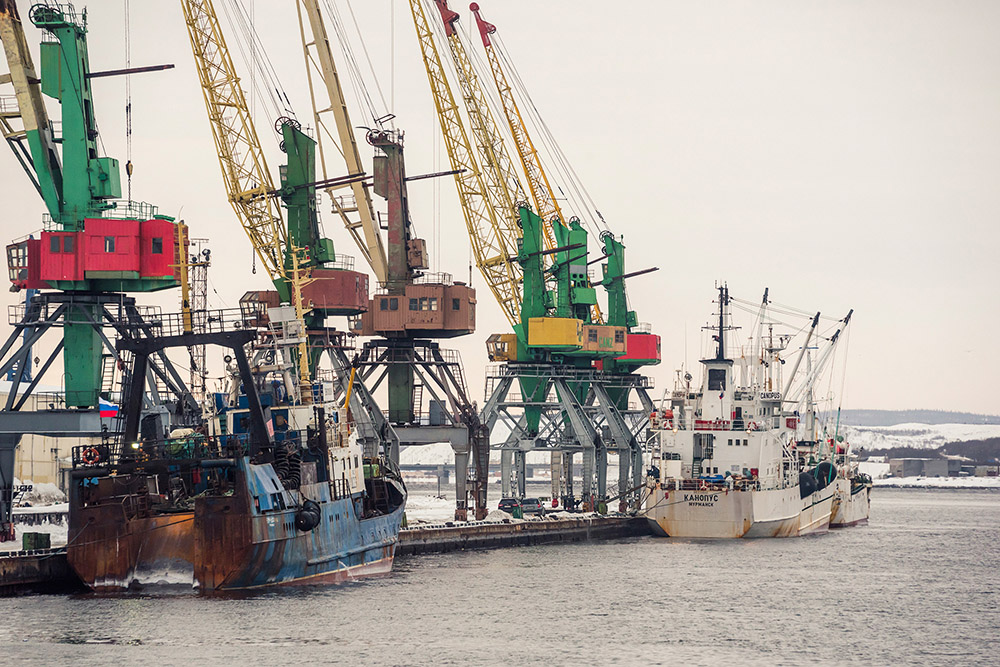
JSC “Murmansk Sea Fish Port” is equipped with reloading mechanisms. The maximum cargo carrying capacity of portal crane is 20 tons. The floating crane is engaged when heavy cargoes are to be reloaded.
JSC “Murmansk Sea Fish Port” provides the following range of works/services, connected with cargoes reloading and servicing of the vessels:
- water supply of ships;
- steam supply of ships;
- supply of ships with electric energy;
- waste (garbage) removal;
- removal of solid waste from the ship and its further disposal;
- provide with phone communication line;
- provide with reloading mechanisms (forklifts, portal cranes) in order to fulfil subsidiary works;
- provide with tug boat services to fulfil mooring operations (towing capacity 1600 h.f.)
JSC “Murmansk Sea Fish Port” in accordance with provisions of the Federal Law of 04.05.2011 № 99-FL (“About licensing of certain types of activities”) has got certificates for loading and unloading operations applied to dangerous cargoes on the railway transport (unlimited certificate for all types of danger for goods according to MOPOG Classification). The port has got either a certificate for loading and unloading operations applied to the dangerous cargoes on the inland water transport, in the sea ports (which is unlimited and applied to the following hazard class of cargoes – 1, 2, 3, 4.2, 5.1, 7, 8, 9).
The territory of the cargo area stretches along the berths № 0, 1, 2, 3, 4, 5, 6, 7, 8, 9, 10, 11, 12, 13, 14, 15, 16, 17, 18, 19, 20, 21, 22, 23, 24, pier of the northern cargo area and adjoined areas. The berths were constructed in 1963-1978.
The budgeted depths of some berths reach 8,00 m. The actual maximum working depth of berths of the northern area doesn’t exceed 7,20 m (berths № 10, 11). Due to this, such berths are used for handling the low-tonnage vessels or for a temporary parking of vessels. The area is supplied with roads for auto transport passing and bringing the cargoes. The reloading and other types of works of the fishing ships processing are made on this area.
On the territory of the Southern cargo area the loading-unloading operations are performed, safekeeping and other types of services for fishing, transporting vessels and tankers.
The territory of cargo area is located along the berths № 37, 38, 39, 40, 41, 42, 43, 44, 45 and adjoined areas. The total extension of berths is 1190 m. The berths were built in 1967-1976.
On the cargo area there are covered warehouses and open warehouse areas for cargoes safekeeping. The southern cargo area is equipped with railroad and roads for the cars. Besides, on the territory of the southern cargo area there are fuel oil facilities, which are used for leakage, safekeeping and reloading of fuel products on the vessels. The terminal capacity includes railway infrastructure, with holding capacity of unloading amount of 8 tanks; trestlework; 3 tanks of total volume of 9 000 m3; system of oil pipelines.
Coaling terminal (base)
The total area of coaling terminal is approx. 73 000 m2. The terminal area stretches along the berths №5, 6 and adjoined territory. On the territory of coaling terminal loading operations of bulk cargo (coal) and general cargo are made as well as safekeeping and other types of services of transport vessels. Reloading of the bulk cargo is performed in the following order: railway carriage – warehouse – transport means and vice versa. The cargo area is equipped with railroad and road for cars. At present the berth №5 is put into operation. It has the following dimensions: length 165 m, width 28.5 m, budgeted depth 9.20 m, working depth 8.80 m.
Railway facilities
The approach railroads of Murmansk sea fish port are adjoined to:
- the northern part of reloading terminal – to station of Murmansk of Oktyabrskaya railroad;
- the southern part of reloading terminal – to station of Kola of Oktyabrskaya railroad.
The total length of the railroad is 32.710 km.
It includes: the northern part of reloading terminal – 7.55 km;
the southern part of reloading terminal – 10.16 km;
Novorybnaya station - 10.429 km.
Delivery/removal of carriages to the places of loading is made by the own locomotives of Murmansk Sea Fish Port from the exhibition railways of Novorybnaya station. We have got two (2) our own locomotives (TEM-2 Y) and a depot.
The current servicing of locomotives and railroad is made on our own, by educated and licensed staff.


